News | October 19, 2016
The Life Cycle of a Flood Revealed
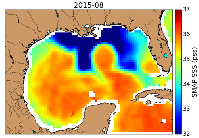
SMAP observed an unusual horseshoe-shaped plume of freshwater (dark blue) in the Gulf of Mexico after Texas flooding in May 2015. Louisiana is above the center of the plume, with Florida on the right and the Texas coastline at upper left. Credit: NASA/JPL-Caltech
A NASA analysis of a 2015 Texas flood is the first to document the full life cycle and impacts of a flood on both land and ocean. Using data from NASA's Soil Moisture Active Passive (SMAP) satellite and other satellite instruments, the study traced the event's chronology -- starting with rains that fell weeks before the flood and ending with an unusually shaped plume of freshwater that lingered in the Gulf of Mexico months later, with a potential for significant impacts on the gulf's marine life.
The analysis was published in the journal Geophysical Research Letters. Séverine Fournier, an oceanographer at NASA's Jet Propulsion Laboratory, Pasadena, California, is the first author.
The flood occurred in southeastern Texas on May 23-24, 2015, when record rainstorms topped off weeks of sustained rainfall. According to the National Weather Service, 37.3 trillion gallons of water fell on Texas in May 2015 -- enough to cover the entire state 8 inches deep in water. "The sheer amount of water was shocking," said coauthor JT Reager of NASA's Jet Propulsion Laboratory, Pasadena, California. "Of course it had an impact on land -- 11 people died, and property was lost. We thought, this has to have an impact on the ocean as well."
The research team used measurements from SMAP with observations from five other NASA satellites to create a comprehensive timeline and map of the flood and its regional effects. SMAP measures both soil moisture (water retained in the top few inches of the ground) and sea surface salinity, which allows scientists to calculate how much freshwater is mingled with the saltwater of the ocean.
When so much rain fell on waterlogged soils, there was nowhere for it to go but downstream. South Texas is one of the parts of the country most in need of stream gauges, according to the U.S. Geological Survey, so ground-level streamflow data are limited. The new analysis found that eight Texas rivers drained huge volumes of water into the Gulf of Mexico, with peak discharge rates as high as 60,000 cubic feet of water (1,700 cubic meters) per second.
Ocean currents carried this large plume of freshwater eastward along the Louisiana coastline during June 2015. In July, it merged with the Mississippi River's outflow, the downstream product of spring precipitation and snowmelt high water from 40 percent of the contiguous United States.
The combined Texas and Mississippi plumes formed what Reager calls "a huge, very weird, horseshoe shape" with legs extending southward into the central gulf. "We had never seen a plume shaped like this in six years of observations of sea surface salinity," Fournier said, referring to the European Surface Moisture and Ocean Salinity satellite data. "Looking at the circulation in the gulf, you can say the unusual features of this plume are not due to the Mississippi River. They're due to the Texas flood."
A strong ocean current in the east of the gulf and a warm eddy in the west played roles in forming the horseshoe and pulling its legs southward toward the central gulf.
Although river water is called freshwater, that doesn't mean it's pure H2O and nothing else. Rivers carry pollutants to the sea, and that's what makes the location and size of the freshwater plume important. "Riverine waters bring lots of nutrients to the ocean, and that can have impacts," Fournier explained. Ocean algae use nitrogen and phosphorus in the runoff -- mainly the product of fertilizers -- to grow and multiply, and the algae concentrations can become much larger than normal. When these overabundant algae die, they sink and decompose in a process that uses up the oxygen in seawater, sometimes creating dead zones that are so oxygen-starved no fish or plants can live there.
The Gulf of Mexico has a variable but huge dead zone, usually ranked largest or second largest in the world. Its average area is about the same as the state of Connecticut. The gulf is also one of the world's largest seafood providers. When its dead zone expands, there are impacts to both fish and the regional economy; for example, fishing boats have to travel farther off shore to find fish, leading to higher fuel costs and a less profitable industry.
After the Texas flood, the gulf's dead zone was about 28 percent larger than average: the size of Connecticut and Rhode Island combined. Fournier will delve deeper into the biogeochemical impacts of the flood on the gulf waters in a follow-up study. This type of research could lead to predictive models for the influences of the high levels of pollution on gulf fisheries.
Reager noted that the complementary land and ocean measurements of SMAP greatly facilitated the team's analysis. "With the existing suite of NASA satellites, we have the opportunity to see the full extent of regional water cycle extremes and the impacts of heavy rains, saturation flooding and intense runoff on both land and ocean," he said. "SMAP really provides a new and important complement to the tools in the NASA Earth science tool belt."
Besides SMAP's measurements, the study used a wide array of other NASA observations: precipitation data from the Tropical Rainfall Measuring Mission and Global Precipitation Measurement mission, water storage observations from the Gravity Recovery And Climate Experiment, ocean color observations from the Moderate Resolution Imaging Spectrometer, and altimetric satellite measurements of ocean currents from the Jason series of satellites.
NASA uses the vantage point of space to increase our understanding of our home planet, improve lives and safeguard our future. NASA develops new ways to observe and study Earth's interconnected natural systems with long-term data records. The agency freely shares this unique knowledge and works with institutions around the world to gain new insights into how our planet is changing.
For more information about NASA's Earth science activities, visit:
