NEWS | May 14, 2012
SMAP & SMAPVEX12
First, a little background on SMAP and SMAPVEX12… (you can find more details elsewhere on this web site)
SMAPVEX12 stands for the 2012 Soil Moisture Active Passive (SMAP) Validation Experiment.
The SMAP mission
SMAP is a NASA Earth science satellite mission that uses microwave radar and radiometer instruments to measure soil moisture from space. The radar and radiometer share a six-meter mesh reflector antenna that rotates at approximately 14 revolutions per minute. The instrument system is mounted on a dedicated spacecraft that will be launched into space in October 2014 if all goes well, and will orbit the Earth approximately every 90 minutes at a height of 685 km above the Earth’s surface. The instruments will measure the microwave radiation emitted and scattered from the land surface, and will transmit the measured data down to Earth where the data will be converted into global maps of soil moisture. The maps will also show whether the moisture in the soil is liquid or frozen at any given time.
Why is soil moisture information needed?
Soil moisture information gathered in this manner by “remote sensing” is important for many applications that benefit society such as improving the accuracy of weather and climate forecasts, mitigating natural hazards such as floods and droughts, and helping predict and assess agricultural crop yields. In forthcoming articles we’ll explain more about how measurements of soil moisture and freeze/thaw state from space are made, and why NASA has placed a high priority on launching a satellite to make these measurements. For now, please visit other pages of this SMAP web site to learn more about the mission.
It is not sufficient to produce global soil moisture maps and make them available through a data center to the general public . Scientists, managers and planners who will use the data need to know how accurate the maps are and under what conditions the maps are valid and can be trusted.
This is where field campaigns such as SMAPVEX12 enter the picture. Field campaigns serve two purposes. Before the observing system is launched into space field campaigns are needed to gather data for use in improving the computer models and algorithms used to create soil moisture maps from the satellite data. The data are also used to develop and test methods to establish the accuracies of the soil moisture maps. After launch, field campaign data are used to determine and continuously monitor the accuracy of the microwave measurements and soil moisture maps.
SMAPVEX12

SMAPVEX12 is the primary pre-launch field campaign for SMAP that is taking place near Winnipeg, Canada during the six-week period from June 6 to July 17, 2012. More about why SMAPVEX12 is being held in Canada and what the components of the campaign are will be explained in later articles. For now, you can get a lot of useful information by visiting the Canadian SMAPVEX web site.
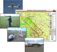
Briefly, the SMAPVEX12 campaign will involve both airborne and ground-based measurements. Two airborne simulator instruments will be flown on separate aircraft and will make SMAP-like measurements as the aircraft fly over agricultural field sites.
At the same time as the aircraft overflights, crews of people deployed across fields on the ground will accurately determine the moisture content of the soil by using automated instruments and also by gathering soil samples manually and weighing and drying the samples. These ground-based or “in situ” measurements will be compared with the remotely sensed measurements derived from the airborne instruments and used to help determine how accurate the remote sensing measurements are. More about this later...
PALS and UAVSAR
The two airborne instruments to be used in SMAPVEX12 are the Passive Active L-band Sensor (PALS) and the Uninhabited Aerial Vehicle Synthetic Aperture Radar (UAVSAR). The PALS and UAVSAR instruments were developed for NASA by the Jet Propulsion Laboratory (JPL) and have been used in several previous field campaigns. More instrument details later...
In forthcoming articles we’ll be following the operations of the PALS instrument in particular, since it closely resembles the SMAP instrument by having both a radar and a radiometer sharing a single antenna viewing the surface at an incidence angle of about 40 degrees. We'll be tracking the PALS instrument as the story of SMAPVEX12 unfolds, as it makes its journey from JPL in Pasadena, California to Grand Junction, Colorado, and to Winnipeg, Canada and back.
Some team members to introduce!
To end this article we'll introduce you to some of the people, SMAP project and others, who are involved in SMAPVEX12. You can expect to hear more about them in the coming weeks.
Dara Entekhabi (MIT) is the SMAP Science Team Lead, Tom Jackson (USDA) is the SMAP Science Definition Team Calibration and Validation (Cal/Val) Lead, Eni Njoku (JPL) is the SMAP Project Scientist, Peggy O’Neill (GSFC) is the SMAP Deputy Project Scientist, and Andreas Colliander (JPL) is the SMAP Project Cal/Val Lead.
You will also be hearing about the Canadian SMAP Science Team led by Stephane Belair (Environment Canada). The Canadian team are international partners of the U.S. team for SMAPVEX12 and are the “hosts” of SMAPVEX12. The Canadian team are responsible for the site logistics and for managing the ground data acquisitions during SMAPVEX12.
The JPL PALS instrument team for SMAPVEX12 consists of Seth Chazanoff, Barron Latham, Ian O’Dwyer, William Chun, and Steve Dinardo.
The ground sampling teams are made up of scientists, students, and technical staff from several institutions on both the U.S. and Canadian sides. You will be hearing about many of them in the weeks ahead. If I have not mentioned any key participants above specifically by name you can be sure they will appear later!


