NEWS | June 15, 2012
On the Twin Otter
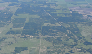
Forest and pasture region at the northern end of the experiment area.
On the second science data acquisition flight of PALS (on June 12) I got to fly on board the Twin Otter aircraft for the flight segment after the mid-day refueling stop at Winnipeg airport. Due to the minimal requirement for a second PALS operator on this flight I took Ian’s place on the plane while Seth continued to be in charge of the PALS instrument operation.
The day was beautiful, the skies mostly clear and the ride very smooth (the going can easily get bumpy on a small plane like the Twin Otter) at about 8500 ft altitude as planned for this flight.
From the bird-view perspective the visual surveying of our experiment domain’s features is fascinating. It was easy to make the distinction between the agricultural area on the southern side and the more forested region on the northern side.

The huge one-square-mile fields following each other form an endlessly extending dull landscape on the ground, but from the air they form a quickly varying mosaic with shapes and colors in almost all combinations. The northern-edge river, very detectable in our microwave imagery, was also very easy to capture visually from the big windows of the aircraft.
An extremely cool feature on the aircraft is the bubble windows; one of the regular windows on each side of the plane is replaced by a window that curves outwards so that it is as if you could stick your head outside the aircraft. The view from these windows is amazing and allows you to look straight up, down, front and back. It is indeed almost like you are outside the aircraft!
