News | July 24, 2016
SMAP Observatory Looks at Tropical Storm Estelle's Winds

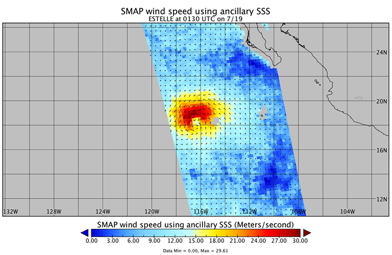
SMAP data were used to estimate ocean winds around Tropical Storm Estelle. On July 19 at 0130 UTC, SMAP data showed that strongest surface winds around Estelle were near 30 meters per second (67.1 mph/ 108 kph).
The strongest sustained winds in the Eastern Pacific Ocean's Tropical Storm Estelle covered every quadrant of the storm except the southern area, according to data from NASA's SMAP satellite.
NASA's SMAP is the Soil Moisture Active Passive observatory but can also be used to estimate winds over the ocean. On July 19 at 0130 UTC (July 18 at 9:30 p.m. EDT), SMAP data showed that strongest surface winds around Tropical Storm Estelle were near 30 meters per second (67.1 mph/ 108 kph). Those winds were circled the storm from west to north to east. Only the winds in the southern quadrant of the storm were less strong, near 18 meters per second.
SMAP is a polar orbiting satellite that is designed to measure the amount of water in the top 5 cm (2 inches) of soil everywhere on Earth’s surface. However, it can also be used to estimate the sea surface salinity under normal ocean conditions and may also be used to estimate ocean wind vectors in extreme wind speed events such as tropical cyclones or hurricanes.
At 11 a.m. EDT (1500 UTC) on July 20, 2016, the center of Tropical Storm Estelle was located near latitude 19.2 degrees north and longitude 123.3 west. That's about 900 miles (1,450 km) west-southwest of the southern tip of Baja California, Mexico. Estelle was moving toward the west near 13 mph (20 kph), and the National Hurricane Center (NHC) said this general motion is forecast to continue today. A motion toward the west-northwest with some increase in forward speed is expected tonight through Thursday.
Estelle's estimated minimum central pressure is 990 millibars. Maximum sustained winds remain near 70 mph (110 kph) but gradual weakening is expected during the next 48 hours.
NHC Forecaster Cangialosi said that Estelle is moving through sea surface temperatures near 26 degrees Celsius (78.8 degrees Fahrenheit) and will be moving over progressively cooler water during the next few days. Tropical cyclones need at sea surface temperatures of at least 26.6 degrees Celsius (80 degrees Fahrenheit) to maintain strength and cooler waters sap the storm's ability to develop the thunderstorms to keep it going.
In addition, NHC noted that Estelle will be moving into drier air and increasing westerly wind shear. Both of which will weaken the storm. Estelle is expected to become a post-tropical cyclone by July 22.


