The SMAP spacecraft carries two instruments, a radar (active) and a radiometer (passive), that together will make global measurements of land surface soil moisture and freeze/thaw state.
Instrument Configuration & Spatial Resolution
The radar and radiometer share a single feedhorn and reflector. The deployable mesh reflector is offset from nadir and rotates about the nadir axis at 14.6 rpm, providing a conically scanning antenna beam with a surface incidence angle of 40°.

The 6 m (20 foot) antenna weighs 65.5 kg (144 lbs.) and is made of gold-coated mesh. The feedhorn sent out radar pings and received radar returns. It has been collecting microwave emission from the same points Earth’s surface for the radiometer.
Instrument Design and L1 Data Product
Frequency & Polarizations
The SMAP instrument incorporates an L-band radar (VV, HH, and HV polarizations) and an L-band radiometer (V, H, and 3rd and 4th Stokes parameter polarizations).
The L-band frequency enables observations of soil moisture through moderate vegetation cover, independent of cloud cover and night or day. Multiple polarizations enable accurate soil moisture estimates to be made with corrections for vegetation, surface roughness, Faraday rotation, and other perturbing factors.
Radar Resolution and Gridding
The SMAP radar employed unfocused SAR processing. The range and azimuth resolutions were determined by the unique antenna scan geometry. The SAR single-look samples (time-ordered) were averaged (multi-looked) onto a swath-oriented 1-km grid to form the L1C_S0_HiRes product. The grid posting of the L1C_S0_HiRes product was fixed at 1 km but the spatial resolution, number of looks, and signal-to-noise ratio (SNR) vary across the swath.
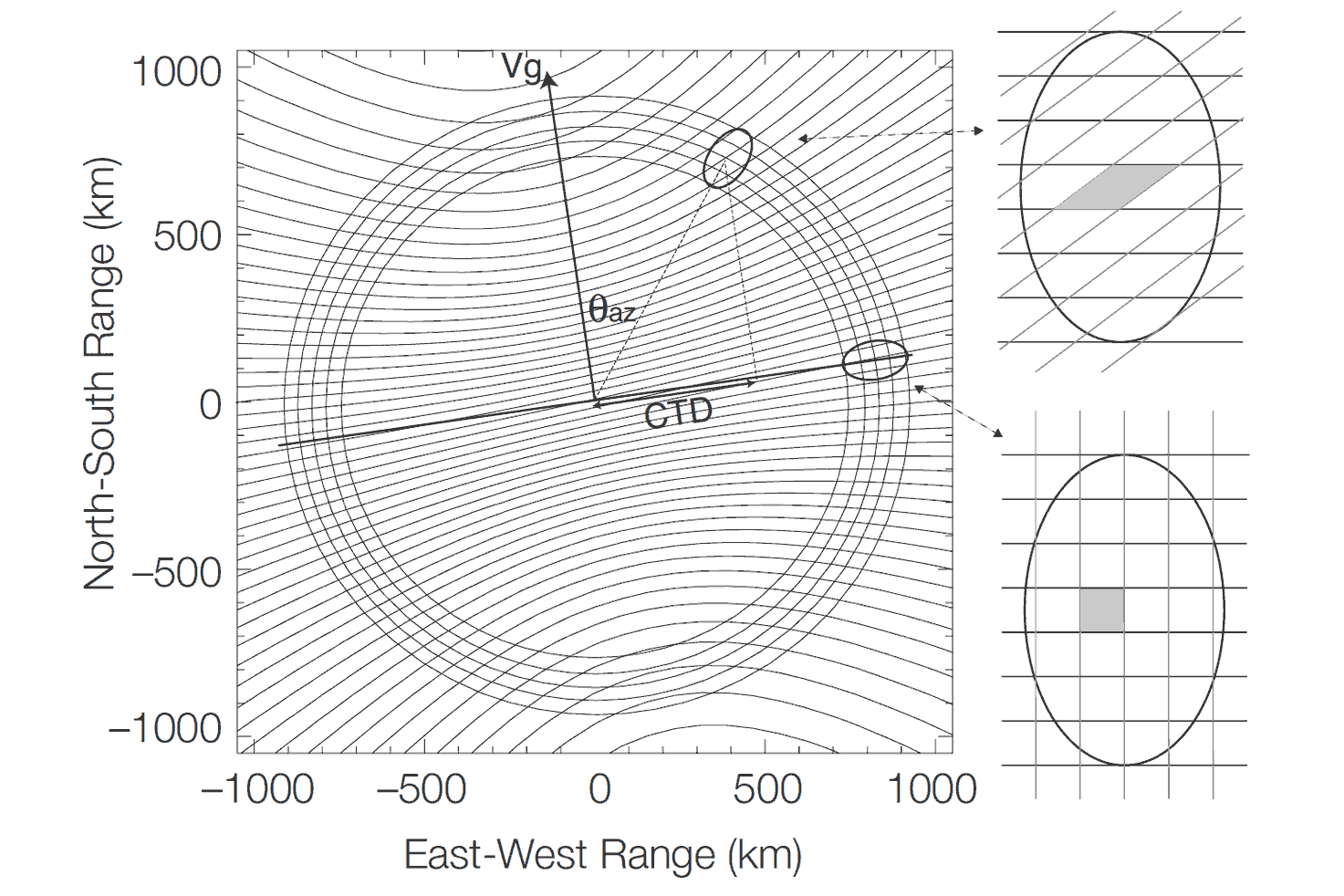
This Range-Range plot illustrates the radar measurement geometry showing the range and Doppler contours. The real aperture radar footprint ellipse is shown at two representative azimuth scan angles. The radar 1 MHz bandwidth yielded a ground range resolution of ~250 m. The Doppler diversity is maximum at a scan angle perpendicular to the satellite velocity (swath edge), leading to an azimuth single-look resolution of ~450 m. The single-look resolution degraded as the scan angles approached the satellite velocity vector. The measurement loop geometry of a radar swath showing the field of view orientations at two azimuths is shown. Vg is the observatory’s velocity vector.

Azimuth resolution varied with the field of view distance from the center of the track (satellite nadir path on Earth’s surface). The single-look data samples from successive fore-look scans were oriented and overlap relative to the 1-km grid. Figure 3 is a schematic illustration and is not drawn accurately to scale. This is a schematic representation, not to scale, of the orientation and overlap of single-look data samples from leading segments of successive loops. The grid is composed of 1 km squares.
Why combined active and passive?
The initial science goal was to combine the attributes of the radar observations (high spatial resolution but lower soil moisture sensitivity) and radiometer observations (higher soil moisture accuracy but coarse spatial resolution).

The provision of constant incidence angle across the 1000-km swath simplified the data processing and enabled accurate repeat-pass estimation of soil moisture and freeze/thaw. Lower resolution (40 km) but more accurate soil moisture data from the radiometer were combined with higher resolution (3 km) but less accurate moisture data from the radar to provide accurate maps with resolution of 10 km. After the failure of SMAP radar in July 2015, data from European Union’s Copernicus Sentinel-1 C-band radar has been used as a substitute.

