SMAP Validation Experiment 2012 (SMAPVEX12)
SMAPVEX12 is the primary pre-launch field campaign for SMAP established to provide data for algorithm evaluation and testing and applications development. Several agencies in the U.S. and Canada are cooperating in the SMAPVEX12 data acquisition, processing and analysis.
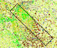
The ground and airborne data acquisition phase of SMAPVEX12 took place over a period of approximately six weeks from June 6 to July 19, 2012 in an agricultural region south of Winnipeg, Manitoba (Canada). The campaign was organized jointly with the Canadian SMAP Science Team who were responsible for coordinating the site logistics and ground data sampling.
The Summary Presentation provides an overview of the campaign objectives and field sites.
Study area: approx.13km x 70km
Sampled sites: 55 Ag-land fields, 5 forested sites
Landcover: cereals (32%), canola (13%), corn (7%), soybean (7%), grassland & pasture (16%)
The Canadian SMAPVEX12 Web Site provides further information on the experiment objectives, field sites, data acquisitions, and participants.
Complete details of the campaign are provided in the SMAPVEX12 Experiment Plan
Visit the SMAP Blog Page for SMAPVEX12 for information on the campaign and related topics.
Current Status
All SMAPVEX12 experiment objectives were satisfied including:
- Observing a wide range of soil moisture conditions
- Observing a wide range of vegetation types and vegetation water content levels
The SMAPVEX12 data are archived at NSIDC. SMAP Cal/Val Workshops in November 2012 and March 2013 focused on the campaign results
For further information on the U.S. components of SMAPVEX12 please contact: Dr. Thomas Jackson (USDA) or Dr. Andreas Colliander (JPL)
