NASA
Jet Propulsion Laboratory
California Institute of Technology
Skip Navigation
menu
close modan
Multimedia
SMAP in Earth Orbit
A short video animation demonstrating the SMAP spacecraft
PREVIEW
Related
The figure shows standard deviation of the difference between satellite observations and ECMWF model values for ASCAT soil moisture (m3.m-3).
Global Near-Real-Time Monitoring of Soil Moisture
Alongside the launch of SMAP, NASA pioneered an early adopter program to apply the data from the SMAP satellite to a variety of real-world applications.
SMAP 2018 EA Update (Long Version)
A United Launch Alliance Delta II rocket with the Soil Moisture Active Passive (SMAP) observatory onboard is seen in this long exposure photograph as it launches from Space Launch Complex 2, Saturd...
SMAP on its way!
Shows the swath path illustrating the scanning pattern of the antenna.
Swath Path 2
A simple illustration of the major elements of the energy cycle is shown in the figure.
The Energy Cycle
The colored curves demonstrate how the production of carbon from an ecosystem has changed over 25 years and how it varies over a year.
Graph of Freeze/Thaw Transitions
NASA doesn’t study just the stars and planets; it is also concerned with the soil beneath your feet. Studying the moisture in the top two inches of the soil from space with a satellite named "SMAP"...
NASA's Earth Minute: Dishing the Dirt
800 million people world-wide go hungry. Can a NASA satellite help when a food crisis is caused by drought?
Can data from a NASA satellite help during a food crisis?
SMAP boom deployment animation
SMAP Boom Deployment Animation
An animation that shows how SMAP gathers data.
SMAP Animation - Gathering Data
Measurement loop geometry of a radar swath showing the field of view orientations at two azimuths. Vg is the observatory’s velocity vector.
Geometry of Radar Swath
The SMAP Observatory will be launched into Earth orbit aboard a Delta II rocket. The specific version of the Delta II used for SMAP employs two stages using liquid rocket engines, supplemented by t...
SMAP Observatory Labeled 2
The USDA National Agricultural Statistical Service (NASS) has launched a web-based U.S. crop vegetation condition assessment and monitoring application: VegScape (http://nassgeodata.gmu.edu/VegScap...
VegScape Map
A video about the challenges of testing the largest rotating mesh antenna ever launched into space.
Technical Origami
The water cycle is illustrated here.
The Water Cycle
The water cycle refers to the movement of water between different parts of the Earth’s environment, including the atmosphere, natural reservoirs such as oceans and lakes, and the soil and rock form...
The Water Cycle 2
SMAP Sea Surface Salinity measurements reveal freshwater from the Amazon entering the Atlantic and being carried by ocean currents.
Salinity Data Show the Movement of Freshwater From the Amazon
A trailer for the SMAP mission
SMAP Trailer
Promotional video for the NASA's Earth Campaign
NASA's Earth Campaign
A 3D interactive model of NASA's SMAP spacecraft.
SMAP 3D Model
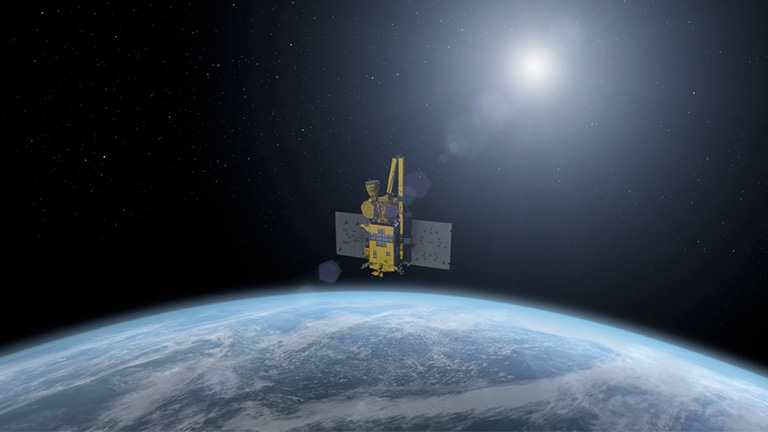
Artist’s conception of SMAP taking data from orbit.
SMAP Taking Data From Orbit
The full extent of SMAP’s flight and ground operations from Launch through the end of the prime mission include data taking, ongoing calibration and validation of the data, and application of the d...
SMAP Operations Chart
An animation of the SMAP mission
SMAP animation - full version
SMAP Observatory labeled and combined.
SMAP Observatory Labeled Combined
NASA's SMAP and University of Texas scientists are rounding up critical soil information for managing the Lone Star State's limited water.
How Dry Is Texas? SMAP, TxSON Network Aim to Find Out
You Might Also Like
Results of a study reveal that SMAP soil moisture retrievals are generally better than AMSR2 soil moisture data.
Validation Analysis of SMAP Products Using Ground-Based Measurements
NASA scientists are auditioning the radar aboard a European satellite to see how well it stands in for the radar that failed aboard the U.S. space agency’s newly launched Soil Moisture Active Passive (SMAP) satellite in July.
NASA Focused on Sentinel as Replacement for SMAP Radar
SMAP data provide another way to see flooding in South Carolina.
Devastating Carolina Floods Viewed by NASA's SMAP
SMAP’s radiometer, which measures temperatures on Earth’s surface, can do more than previously thought, and the spacecraft remains healthy, scientists say.
Scientists Hopeful About SMAP After Loss of Radar
Discovery Channel features students exploring Mount Kilimanjaro. They will learn about collecting environmental data on the mountain’s six biomes and meet a NASA Jet Propulsion Laboratory scientist to discuss the SMAP Mission, a satellite that measures the Earth’s soil moisture.
Students Learn About SMAP during Mount Kilimanjaro Expedition
Dara Entekhabi, the science team leader of NASA’s Soil Moisture Active Passive (SMAP) satellite, was selected by the American Geophysical Union (AGU) to receive the 2015 Hydrologic Sciences Award.
Dara Entekhabi Is Recipient of 2015 Hydrologic Sciences Award
NASA's SMAP satellite observatory conducted a field experiment as part of its soil moisture data product validation program in southern Arizona.
SMAPVEX 15 Field Campaign Measures Soil Moisture Over Arizona
NASA scientists are on a mission to map global soil moisture, and through SciStarter, they’re teaming up with citizen scientists to gather valuable data from the ground to complement and validate what is seen from space.
NASA and SciStarter Enlist Citizen Scientists to Examine Soil Moisture
News from the fourth Soil Moisture Active Passive (SMAPEx-4) field campaign, carried out in Yanco, NSW, Australia, from May 1-23, 2015. This field experiment is part of the CalVal activities for the NASA SMAP mission.
Notes from the Field
NASA-funded study finds that Texas’ historic rainfall and resulting soil moisture could strengthen a storm moving inland from the Gulf of Mexico.
'Brown Ocean' Effect May Bedevil Soggy Texas as Storm Nears
An assessment of surface soil moisture is necessary for applications such as weather forecasting, climate change modeling, monitoring of agricultural productivity, water resources management, drought prediction, flood area mapping, and ecosystem health monitoring.
Mission to Monitor Soil Moisture with Active-Passive Remote Sensing
“We’re entering the golden age of satellite missions for water,” says Jay Famiglietti, NASA’s senior water scientist. His research team is mapping the dwindling water supply of the drought-gripped western United States.
California Has No Idea How Much Water It Has Left; NASA Can Help
SMAP’s measurements will help scientists to understand the circulation of water and carbon. The carbon cycle has more branches than the water cycle; it transfers from the air, in the form of carbon dioxide, to soil, rocks, surface water and frozen surfaces.
SMAP Will Help Scientists Understand Circulation of Water and Carbon
With its antenna spinning at full speed, NASA's new Soil Moisture Active Passive (SMAP) observatory has successfully re-tested its science instruments and generated its first global maps, a key step to beginning routine science operations.
NASA Soil Moisture Mission Produces First Global Maps
Kent Kellogg will be the featured speaker May 11 when the La Cañada Flintridge Coordinating Council holds its annual Les Tupper Awards ceremony in von Karman Auditorium at the Jet Propulsion Laboratory. The event begins at 7 p.m.
SMAP Manager to Join Tupper Awards
The 20-foot (6-meter) "golden lasso" reflector antenna atop NASA's new Soil Moisture Active Passive (SMAP) observatory is now ready to wrangle up high-resolution global soil moisture data.
It's 'full spin ahead' for soil moisture mapper
Mission controllers at NASA's Jet Propulsion Laboratory in Pasadena, California, have commanded the 20-foot (6-meter) reflector antenna on NASA's new Soil Moisture Active Passive (SMAP) observatory to begin spinning for the first time. The partial spin-up is a key step before science operations.
NASA's New Soil Moisture Mapper Goes for a Spin
NASA's new Soil Moisture Active Passive (SMAP) observatory has successfully completed a two-day test of its science instruments. The observatory's radar and radiometer instruments were successfully operated for the first time.
NASA's Soil Moisture Mapper Takes First 'SMAPshots'
Mission controllers at NASA's Jet Propulsion Laboratory in Pasadena, California, today sent commands to unfurl the massive 20-foot-wide (6-meter) reflector antenna on NASA's new Soil Moisture Active Passive (SMAP) observator. The deployment of the mesh reflector antenna, which supports the collection of SMAP's radar and radiometer instrument measurements in space, marks a key milestone in commissioning the satellite. S
SMAP Completes Key Milestone
Over the past 12 months NASA has added five missions to its orbiting Earth-observing fleet – the biggest one-year increase in more than a decade. NASA scientists will discuss early observations from the new missions and their current status during a media teleconference at 2 p.m. EST Thursday, Feb. 26.
NASA Briefing to Highlight Early Results from New Earth Science Missions
NASA's SMAP has successfully separated from the Delta II rocket off the east coast of Africa, and engineers have successfully established communication with the spacecraft.
NASA Launches Groundbreaking Soil Moisture Mapper
A United Launch Alliance Delta II rocket with the Soil Moisture Active Passive (SMAP) observatory onboard launches from Space Launch Complex 2, Saturday, Jan. 31, 2015, Vandenberg Air Force Base, Calif. S
We have liftoff!
NASA's Soil Moisture Active Passive mission (SMAP) now is scheduled to launch from Space Launch Complex 2 at Vandenberg Air Force Base, California at 6:20 a.m. PST (9:20 a.m. EST) Saturday, Jan. 31, on a United Launch Alliance Delta II rocket. NASA Television coverage of the launch will begin at 4 a.m. PST (7 a.m. EST).
Launch of NASA Soil Moisture Mapping Mission Set for Saturday
This is a wonderful infographic brought to you by Space.com.
How NASA's Soil Moisture Satellite Works (Infographic)
NASA's Soil Moisture Active Passive (SMAP) observatory is perched on the pad at Space Launch Complex 2 (SLC-2), and is set to launch Thursday, Jan. 29, at 6:20 a.m. PST (9:20 a.m. EST) from Vandenberg Air Force Base in California. A United Launch Alliance Delta II rocket will carry SMAP into orbit. The launch window lasts three minutes.
NASA's SMAP Earth Mission Awaits Launch
Precipitation and temperature are part of every weather forecast. Precipitation comes from clouds, clouds are formed of airborne water vapor, and vapor comes from evaporating soil moisture -- so soil moisture governs precipitation.
Building a Better Weather Forecast? SMAP May Help
NASA doesn’t study just the stars and planets; it is also concerned with the soil beneath your feet. Studying the moisture in the top two inches of the soil from space with a satellite named "SMAP" can help weather forecasters predict flash floods, farmers grow more crops, and communities plan for drought.
NASA's Earth Minute: Dishing the DIrt
NASA held a media briefing at 11 a.m. PST (2 p.m. EST) Thursday, Jan. 8, at NASA Headquarters in Washington to discuss the upcoming Soil Moisture Active Passive (SMAP) mission.
NASA Previews SMAP Launch
Scheduled for launch on Jan. 29, 2015, NASA's Soil Moisture Active Passive (SMAP) instrument will measure the moisture lodged in Earth's soils with an unprecedented accuracy and resolution. The instrument's three main parts are a radar, a radiometer and the largest rotating mesh antenna ever deployed in space.
Technology Innovations Spin NASA's SMAP into Space
SMAP will allow for improved weather forecasts that will upgrade predictions for heat stress and virus-spreading rates. In short, SMAP will allow policy makers to plan farther ahead into the future.
New NASA satellite should help scientists better predict rain, drought
SMAP will be working with the Texas Soil Observation Network to help water managers in Texas.
How Underground Sensors In Texas Will Help NASA Predict Drought and Floods
NASA’s innovative soil moisture mapper, a new environmental satellite launching in January, has been fueled up for blastoff from Vandenberg Air Force Base in California.
Soil moisture mapper fueled for January launch
The Latest Images
Latest from SMAP
The launch of NASA’s Soil Moisture Active Passive (SMAP) observatory has been delayed to a targeted launch date of Jan. 31, pending completion of minor repairs to the United Launch Alliance Delta II launch vehicle.
SMAP Earth Mission Launch No Earlier than Saturday
Initial data from SMAP capture the 2015 spring thaw progression over the Northern Hemisphere, with a thaw front extending from predominantly non-frozen southern latitudes to the still-frozen north.
NASA SMAP Images Show Progression of Spring Thaw in Northern Hemisphere
NASA celebrated the 45th annual Earth Day April 17-22 with a variety of live and online activities to engage the public in the Agency's mission to better understand and protect our home planet.
NASA Celebrates Earth Day with Public Events, Online Activities
NASA's SMAP and University of Texas scientists are rounding up critical soil information for managing the Lone Star State's limited water.
How Dry Is Texas? SMAP, TxSON Network Aim to Find Out
SMAP data show surface soil moisture in the Southeastern United States on Oct. 5, 2015 when large-scale flooding was experienced all over South Carolina.
Devastating Carolina Floods Viewed by NASA's SMAP